By Lucy Clarke (@DrLucyClarke)
Everyone is familiar with photography, with the rise of
digital cameras and increasingly high resolution cameras available on mobile phones
and tablets people are photographing everything from their holidays, pets,
family, friends and even themselves. I love photography and enjoy capturing images
of my travels, but I also use photographs in a very different way as part of my
research: rather than just appreciating their aesthetic value I use photographs
to recreate and measure features on the Earth’s surface and in the lab.
In remote areas where it is difficult to access a location
or when looking into the past, photographs can often be the only option
available to explore an area. Historic photographs are therefore extremely
valuable, as they provide a record of what something looked like at various
points in time and so can be used to look at temporal change. This is
especially useful if an extreme event occurs in a location that has never been
measured before, so you can look at the impact the event had. An example of
this is shown below; the 2 photographs show the Poerua alluvial fan in New
Zealand before and after a big event. In 1999 a large rock avalanche occurred
in the headwaters of this system forming a dam in the gorge below, the water
ponded up behind this for 2 days before it finally burst, creating a flood wave
that engulfed the area downstream and caused the river to avulse (move to a new
location) and deposit large areas of gravel on top of the agricultural land.
Using photographs from before and after this event enables identification of the
area of land that has been affected and the new position of the river channel
to try and assess the damage.
 |
|
Aerial
photographs from 1984 (before) and 2005 (after) the 1999 flood event on the
Poerua alluvial fan in New Zealand (Images courtesy of NZ Aerial Mapping Ltd
and GeoSmart)
|
Although it is useful to look at these photographs and see
the changes between when they were taken and what is there now, it doesn’t help
us to actually measure anything or quantify the change. So in my research I use
a technique called photogrammetry,
which allows me to process photographs and extract quantitative data from them.
In its simplest form, photography converts the 3D real world into a 2D image,
and photogrammetry converts this 2D image back into a 3D representation - using
information on the type of camera and lens used to take the image and the
relationship between the camera and the ground at the time that the image was
captured. This requires two overlapping images of the same place which are
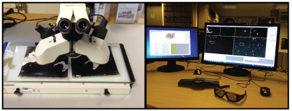
viewed at the same time in a single 3D image, in what is known as a stereo-image. Traditionally, this was
done using a stereoscope (which uses mirrors and viewing lens to fuse the 2
images together when you look at them - like a magic eye picture) but in modern
digital photogrammetry this is done using specialist software on a computer
using a 3D screen and glasses – like when you watch a 3D film at the cinema. In
the digital workflow the images are adjusted according to the camera parameters
and georeferenced using the
coordinates of known positions from the ground to create a true scale representation.
A digital elevation model (a 3D map
of the surface area) can then be extracted and used to measure features, this
gives the same results as it would have done if you were standing on the ground
measuring it.
 |
|
Ways
of viewing images in stereo (a) the traditional method using stereoscope and
(b) my digital photogrammetric computer set up with 3D screen and glasses
|
Photogrammetry is most commonly used with aerial
photography but it can be applied to any overlapping imagery if you have the
correct information. For example, below is a photograph and associated digital
elevation model I created from my alluvial fan experiments, outlined in my
previous blog post: What drives change on alluvial fans?

Photogrammetry software is expensive to purchase and
processing the images can be complex and involves training, so traditionally
photogrammetry has only been used by specialists. But recently there has been a
development in something called Structure
for Motion – this involves taking multiple photographs of objects from
different angles and then uploading these into software that uses
photogrammetric principles to automatically create a 3D model. This software is
available on the web – e.g. Bundler (free to download), Photosynth (free to download) and AgriSoftPhotoscan (the demo version is free, which allows you to create models but not save) - so
you can upload your own photos and have a go at creating your own 3D model from
them!
 |
|
An
example of the 3D model created by Structure
for Motion (Source: Goesele et al, 2007)
|
I first used photogrammetry many years ago for my Masters’
thesis and since then I have incorporated it into all of my subsequent
research, whether it is analysing a field site or an experimental landform. In
my first blog post I mentioned that I am a fluvial geomorphologist (my research is all about
rivers), but since writing that post I have changed jobs and I am now using my
photogrammetry skills in a whole new environment – Antarctica – working for the
British Antarctic Survey in Cambridge. I have just started a new project using an archive of
approximately 30,000 aerial photographs of the Antarctic Peninsula that date
back to the 1940s to investigate how glaciers in this region have changed in
the last 70-80 years, an area little is currently known about. This means that
I am lucky enough to have access to the most amazing photography of the one of
the most remote and stunning places on the planet and will be working with this
for the next couple of years, which I will keep you updated on in future blog
posts.
 |
|
(a)
Part of the archive of aerial photos held at the British Antarctic Survey, examples
of historic aerial photos of the Antarctic Peninsula from (b) 1950s and (c)
1980s
Reference:
Goesele
M., Snavely N., Curless B., Hoppe H. And Seitz S. 2007. Multi-View Stereo for
Community Photo Collections. Proceedings
of ICCV: Rio de Janerio, Brazil: 14-20 October 2007.
|
An interesting read. Photogrammetry in polar regions is fraught with difficulty. The saviour is modern LiDAR which you can use to "tie" the images. Swansea glaciology group have been doing this for years, sadly my research came just before the Lidar revolution.
ReplyDeleteYep BAS uses that technique for creating the maps of Antarctica, but I have no LiDAR in my research. It's all based on aerial photography, but modern GPS kinematic camera we now have at BAS means we can use similar technique with the photography.
DeleteThis comment has been removed by the author.
ReplyDelete